Native Grasslands Around Craigieburn
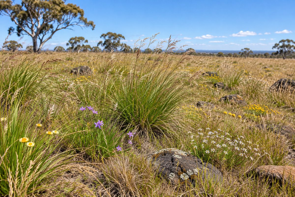
The native grasslands around Craigieburn are rare remnants of a much larger volcanic plain ecosystem. They survive in reserves, creek corridors, road edges and undeveloped parcels across Melbourne’s northern fringe. Some patches look like ordinary open fields. At ground level, they can hold native herbs, lilies and grasses that support threatened wildlife.
These places need careful reading. A green paddock is not always native grassland, while a dry brown patch may contain valuable native plants. The condition also changes through the year. Rain, fire, grazing and mowing can alter what visitors see without changing the ecological value beneath their feet.
This guide explains how to recognise the broader grassland system, where protected remnants fit within it and why connected habitat matters. For more local context, start with Craigieburn Fieldnotes.
Where do the grasslands sit around Craigieburn?
Craigieburn, Victoria sits near the eastern edge of the volcanic plains that spread across much of western Melbourne. The original grasslands did not stop at modern suburb boundaries. They extended across broad basalt plains shaped by old lava flows, shallow soils and seasonal wet areas.
Most intact vegetation has since been replaced or divided by housing, roads, farming and industry. The surviving pieces form an uneven network rather than one large destination. Important remnants occur within conservation land and along waterways. Others remain on land with limited or no public access.
The Craigieburn Grassland Nature Conservation Reserve is one of the named protected areas associated with this system. A reserve boundary does not mean every part is open for casual entry. Visitors should follow current signs, stay outside fenced management areas and use official access information. Conservation reserves may restrict movement to protect plants, wildlife or active land management.
People sometimes confuse local references to Mount Ridley with similarly named places elsewhere. Here, Mount Ridley means the rise and surrounding district in Melbourne’s north, beside Craigieburn. It belongs within the local basalt plain setting. Search results for other Mount Ridley locations do not describe this ecosystem.
What makes this grassland different from an empty paddock?
Native grassland is a plant community, not a lack of trees. Its structure comes from native grasses mixed with small flowering plants. Trees may be absent or scattered because of soil, climate and long-term disturbance patterns.
Tussock grass often provides the most visible structure. The spaces between tussocks matter as much as the grass itself. Native daisies, peas and lilies can grow in those gaps. Small animals use the open ground for movement and warmth. Dense introduced pasture can cover those spaces and push out smaller native species.
The local remnants form part of the wider Victorian Volcanic Plain grasslands. Official vegetation mapping also uses terms such as Western Plains Grassland for related native vegetation on basalt soils. These labels describe ecological communities with known plant structure and environmental conditions. They do not mean every grassy block qualifies.
A useful field clue is variation. Native remnants often contain plants of different heights, bare soil between tussocks and seasonal flowers. Improved pasture tends to show a more even cover of a few introduced species. This clue cannot confirm the status of a site. A proper assessment may require plant records, repeated surveys and checks during the right growing season.
Dry weather causes a common mistake. Many native plants retreat underground or become hard to see after flowering. A site that looks sparse in summer can change after autumn rain. One quick visit is therefore a poor basis for deciding that land has little value.
Why do small remnants still matter?
A small remnant can preserve plant species that have vanished from nearby developed land. It can also act as a resting point between larger habitat areas. This makes size important, but not decisive.
Habitat fragmentation occurs when one continuous area is split into isolated pieces. A road may leave apparently similar grass on both sides, yet become a serious barrier for a small animal. Housing can also change drainage, introduce weeds and increase pressure from pets.
Isolation causes ecological problems over time. Plants may receive less pollen from other patches. Animals face longer and riskier trips between feeding or breeding areas. A local loss can then become permanent because the species cannot return from another remnant.
This is why Nature conservation around Craigieburn must consider the spaces between reserves. Creek margins, drainage land and suitable roadside vegetation can help connect habitat. Poorly planned work within these narrow links can cut off a larger protected patch from the rest of the system.
Small areas also hold evidence about the former plain. Their soils, plant mix and seasonal wet spots help ecologists understand what once occurred across land now covered by streets. Protecting them retains living reference points for restoration elsewhere.
Which threatened animals use this habitat?
The Striped legless lizard is closely linked with native temperate grasslands in south-eastern Australia. It has a snake-like body but belongs to the lizard group. Small external features are hard for an untrained observer to use, so any possible sighting should be left undisturbed and reported through an appropriate wildlife record system.
A Legless lizard shelters beneath grass, soil cracks, rocks and ground debris. Removing rocks or lifting material for a better look can damage its shelter. Replacing an object does not fully undo the disturbance because temperature and moisture conditions may have changed.
The Fat-tailed dunnart is a small native marsupial found in open country, including grassland habitat. Its survival depends on more than visible grass cover. Ground cracks and shelter sites can be vital. Broad clearing or heavy soil disturbance may remove these features even when some grass remains nearby.
The Growling grass frog has a different habitat need. It relies on water bodies and waterways with suitable aquatic vegetation, but the surrounding land affects movement and shelter. Wetlands linked to grassland and creek corridors can therefore support the frog better than isolated water surrounded by hard surfaces.
These species show why habitat should not be judged by scenery. A low field may contain shelter below the grass. A plain-looking wet area may become useful breeding habitat under suitable conditions. The key question is how vegetation, water and shelter work together.
How do Merri Creek and Malcolm Creek fit into the grassland system?
Merri Creek is part of the ecological structure running through Melbourne’s north. Its upper catchment passes through country shaped by basalt geology and former native grasslands. The creek adds wet habitat and a movement corridor to an otherwise open grassland setting.
Malcolm Creek flows through Craigieburn and connects with the wider Merri Creek catchment. Its shared path gives residents an accessible view of a changed creek corridor, but it should not be treated as proof that all nearby vegetation is intact native grassland. Much of the urban corridor has been altered, planted or managed for drainage and recreation.
The value of a creek lies partly in connection. Waterways can link wetlands, grassy edges and larger remnants. Birds may move along them with ease. Ground-dwelling animals face more barriers where paths, roads and closely cut lawns break the cover.
Water movement also carries risk. Weed seed, litter and polluted runoff can travel from streets into creek habitat. Works upstream can change erosion or sediment downstream. Protecting a grassland patch while ignoring its catchment leaves a major source of damage untouched.
Visitors who want details about the path itself should use the separate Malcolm Creek walking guide. The grassland question is narrower: the creek forms part of the ecological connection, while the remaining native grasslands require their own identification and protection.
What threatens the remaining patches?
Direct clearing causes the clearest loss. The slower damage can be harder to see. Introduced grasses may spread until native herbs have little room. Soil disturbance can favour weeds and destroy cracks used by small animals.
Changed fire patterns also affect plant structure. Some grassland plants respond to carefully timed ecological burning, but fire is not a simple cure. Season, frequency and site condition influence the result. Planned burns require trained land managers, permits and follow-up weed control.
Mowing has similar limits. It may reduce tall introduced growth in one place and harm flowering native plants in another. A neat appearance is not a sound conservation goal. Management should respond to the species present and the purpose of the site.
Dumped garden waste is another direct threat. Lawn clippings and soil can introduce weeds or add nutrients that favour aggressive plants. Even material sold as native mulch may smother the small gaps that grassland herbs need.
Recreation adds pressure when people leave formed paths. Repeated trampling compacts soil and creates informal tracks. Dogs may disturb wildlife or enter fenced restoration areas. These impacts grow when many visitors make the same small choice.
How can you visit without damaging the grassland?
Use a legal public entry point and obey the signs at the site. Reserve conditions can change during works, fire management or ecological surveys. A map found in an old article may no longer show the right access.
- Stay on formed paths where they exist.
- Keep dogs under the control required by local signs and never take them into prohibited areas.
- Leave rocks, plants and fallen material in place.
- Clean mud and seeds from footwear before moving to another reserve.
- Photograph flowers without picking them.
- Record wildlife from a distance and avoid sharing the exact location of sensitive species publicly.
The best time to see plant variety often follows seasonal rain, when more species are actively growing or flowering. That does not create permission to enter closed land. A view from a public path can still reveal tussock structure, wet depressions and the sharp boundary between remnant vegetation and developed ground.
Take care with wildlife identification. A blurred photograph should remain an uncertain record. Uploading it to a recognised citizen-science platform can help experienced identifiers review the sighting. Never handle an animal to improve a photograph.
What can local residents do beyond visiting?
Residents can support grassland protection by reporting dumping, damaged fences or new weed outbreaks to the relevant land manager. Include a clear location and a photograph taken from a lawful position. A precise report is easier to act on than a broad complaint.
Garden choices can reduce pressure near habitat. Prevent invasive plants from escaping, keep soil and clippings out of drains, and contain pets. These actions are most useful for homes near creek corridors or reserve edges.
Development notices also deserve close reading. The presence of dry grass does not prove a block is ecologically empty. Biodiversity reports should account for season, survey method and the possibility of threatened species. Residents can ask whether surveys covered the right time of year and whether habitat connections were considered.
Restoration work should follow local ecological advice. Planting generic native grasses may create cover without rebuilding Western Plains Grassland. The source of seed, the existing soil and the mix of small herbs all affect the result. Protecting an original remnant usually retains values that a new planting cannot quickly replace.
Before your next local walk, check the current reserve map, choose a legal formed path and record what you see without stepping into the grassland.